 Antiques (US)
Africa Maps
Asia Maps
Australia/Oceania Maps
Celestial Maps
Central America/Caribbean Maps
Curiosities Maps
Digital Maps
Europe Maps
Map & Globe Mixed Lots
Map & Globe Reproductions
North America Maps
South America Maps
World & Celestial Globes
World Maps

-
$137.50

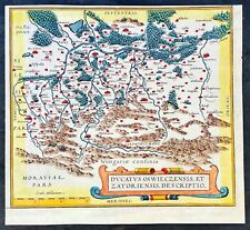 1574 Ortelius Antique Map of Oswięcim & Zator Regions Southern Poland Carpathian
-
$250.00
 400 YR ANTIQUE MAP SPAIN SEVILLE PRINT MUNSTER, ESPAÑA, SEVILLA MAPA GRABADO
-
$425.00
 Original Map Of The Azores By Abraham Ortelius, 1573
-
$935.00
 1541 Fries Ptolemy Antique Map The Caucasus Georgia, Armenia, Azerbaijan, Russia
-
$13.95
 1530s Old Map of the World as seen from the North & South Poles - 16x24
-
$118.66
 Sebastian Munster. woodcut map. De insulis Britannicus Albione c1550
-
$26.95
 1565 Exploration World Map Large Terra Wall Print 24x42
-
$500.00
 1581 ORTELIUS POLONIAE POLAND MAP ORIGINAL FRENCH VERSION VERY GOOD
-
$18.95
 1940s Vintage Maine Picture Map Antique Maine State Map Wall Art Decor 1559
-
$950.00
 Turcici Imperii Descriptio . . . published by Abraham Ortelius, 1595
-
$181.11
 TARTARIAE CALIFORNIA c1590 BY ABRAHAM ORTELIUS GENUINE ORIGINAL ENGRAVED MAP
-
$15.25
 1940s Vintage Arizona Picture Map Liozu Arizona State Map Wall Art Decor 1518
-
$20.95
1565 Known World Map Gastaldi Bertelli Americas - 20x36
-
$137.50
 Corfu Ionian Island Greece w/ Sea Monsters ca. 1595 Porcacchi Porro antique map
-
$28.10
 FIRST MAP TO SHOW THE AMERICAS PORTOLAN WORLD MAP 1500 A.D SUPERB MOUNTED CHART
-
$140.00
 Antique Map of Paris Lutetia Vulgo Anno 1575 Reprinted in Late 1800s
-
$218.58
 CYPRUS INSULA c1590 BY ABRAHAM ORTELIUS GENUINE ORIGINAL ENGRAVED MAP
-
$16.95
 "The New World" 1562 Historic Exploration Map - 20x24
-
$13.95
 1590 Iceland Sea Monsters Historic Vintage Exploration Map - 16x24
-
$16.95
 1940s Vintage Manhattan Picture Map Antique New York City Map Wall Art 1564
-
$20.95
 1500s Waldseemuller Map of America - First Map to Name "America" - 20x36
-
$975.00
 c. 1596 ORIGINAL MAP OF THE AMERICAS, ORTELIUS -MAGINI
-
$225.00
 Antique Original 1564 Braun & Hogenberg Handcolor Engraving of Alhama de Granada
-
$25.95
 1576 Constantinople Ottoman Empire Historic Vintage Style Wall Map - 24x36
-
$16.95
 1940s Vintage California Picture Map Antique California State Map Wall Art 1563
-
$493.37
 AMERICA AMERICAE NOVI ORBIS c1590 BY ABRAHAM ORTELIUS GENUINE ORIGINAL MAP
-
$23.95
1562 America New World Map Exploration Art Print - 24x28
-
$17.95
 Map of the Pacific Ocean with America 1589 Vintage Style Old World Map - 20x28
-
$499.61
 1568 REAL RARITY ,Genuine Latin Map LAND OF THE DEAD BOOK OF MATTHEW ,Vincentius
-
$247.50
 Middle East Holy Land Israel Palestine Syria Arabia 1579 Petri miniature map
-
$69.95
 Vintage Terrestrial World Globe With Brass Stand
-
$40.00
 خريطة القاهرة 1955 خارطة خريطه Vintage Map of Cairo Egypt Maps Atlas مصر
-
$24.95
 Paris 1550 Historic City Map - Vintage France Plan de Paris - 24x32
-
$17.95
 1590s “Colonial Virginia” Vintage Style Roanoke Settlement Map - 20x28
-
$24.95
 1570 China Japan America Unusual Historic Map - 24x32
-
$13.95
Colonial Virgina 1590 Vintage Style John White Map - 18x24
-
$218.58
 EAST INDIES ASIA c1590 BY ABRAHAM ORTELIUS GENUINE ORIGINAL ENGRAVED MAP
-
$129.00
 Professionally Framed 1576 Map Of Paris France Lithograph By Rossingol
-
$99.00
 J4649 NETHERLANDS 1555 ENGRAVED/ PRINT OAK FRAMED SEE DESCRIPTION
-
$197.50
 Antique Print-View of the city of Amsterdam-Netherlands-Munster-Anonymous-1592
-
$17.95
 1570 Palestine Orbis Terrarum Historic Old Map - 20x28
-
$16.95
 1940s Vintage Wisconsin Picture Map Wisconsin State Map Wall Art Decor 1565
-
$13.95
1507 Historic Map by Waldseemuller - First Map to Name "America" - 14x24
-
$218.58
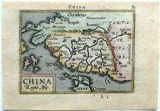 CHINA REGIO ASIE c1590 BY ABRAHAM ORTELIUS GENUINE ORIGINAL ENGRAVED MAP
-
$13.95
 1561 London Historic Old City Map - 16x24
-
$13.95
1589 Mars Pacifici Historic Vintage Style Unusual New World Wall Map - 18x24
-
$25.95
 1595 Sir Francis Drake's Old World Voyages Exploration Map Poster - 24x36
-
$13.95
 1580 Caribbean & Cuba Historic Vintage Style New World Map - 18x24
-
$355.50
 ANTIQUE Braun & Hogenberg LYON FRANCE MAP Engraving from CITIES of the WORLD
-
$13.95
 Germania 1570 Orbis Terrarum Historic Ortelius Map - 18x24
-
$16.95
 1590s “Floridae Americae” Vintage Style Exploration Map - 20x24
-
$18.95
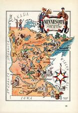 1940s Vintage Minnesota Picture Map Minnesota State Map Wall Art Decor 1561
-
$13.95
 1585 Sir Francis Drake Cartagena Sea Monster Map - 18x24
-
$18.95
 View of London 1560 Historic Old Map - 20x30
-
$18.95
 1940s Vintage Boston Picture Map Liozu Boston Print Wall Art Decor 1560
-
$125.00
 Antique Woodcut View Trier Germany Sebastian Munster Cosmographia Italian 1575
-
$13.95
 1570 Orbis Terrarum Europe Historic Vintage Map - 18x24
-
$618.28
 ORBIS TERRARUM THE WORLD c1590 BY ABRAHAM ORTELIUS GENUINE ORIGINAL ENGRAVED MAP
-
$16.16
 1940s Vintage Idaho Picture Map Liozu Idaho State Map Wall Art Decor 1519
-
$17.95
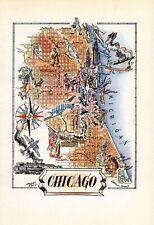 1940s Vintage Chicago Picture Map Liozu Chicago Illinois Map Wall Art Decor 1562
-
$23.56
 Dublin Large Medieval Map 66cm x 86cm (1978) Scarce
-
$15.25
 1940s Vintage New Hampshire Picture Map Antique State Map Wall Art Decor 1525
-
$875.00
 c.1586 ORIGINAL ANTIQUE WORLD MAP, OVAL PROJECTION - TOMMASO PORCACCHI, VENICE
-
$350.00
 RHINOCEROS AFTER ALBRECHT DURER 1550 COSMOGRAPHY OF MUNSTER RARE ANTIQUE VIEW
-
$24.95
 Africa 1570 Orbis Terrarum Historic Ortelius Map - 24x32
-
$185.00
 Antique Map, Bloys, George Braun & Frans Hogenberg, 1572-1617
-
$24.95
 Sir Francis Drake 1585 West Indies Santiago Map - 24x32
-
$49.96
 Netherlands, evacuation of the Spanish from Utrecht, jeton 1577
-
$18.95
Iceland 1590 Illustrated "Islandia" Historic Old Map - 20x30
-
$13.95
1570 Orbis Terrarum Africa Historic Vintage Map - 18x24
-
$17.95
1585 Sir Francis Drake Voyages Cartagena Columbia Map - 20x28
-
$24.95
1590 John White’s Virginia Historic Vintage Style Unique Wall Map - 24x32
-
$18.95
1560's London Interesting Old Historic Map - 20x30
-
$13.95
1550 Paris France Vintage Historic City Map - 18x24
-
$49.95
 5 Map Set Illustrating Sir Francis Drake's West Indian Voyage circa 1595 18"x24"
-
$4.72
 1952 Vintage EGYPT, SUDAN & ETHIOPIA Antique Atlas Map - Britannica World Atlas
-
$13.95
 1570 Orbis Terrarum Italia Historic Vintage Map - 18x24
-
$45.00
 Vintage Saxton’s Map of England and Wales 1579 -High Quality Old Map / Poster
-
$1495.00
 Antique 1597 "Map View Of Lucerne" (Switzerland) Etching by Martinus Martini
-
$17.95
 1585 Voyages of Sir Francis Drake Atlantic Ocean Map - 20x28
-
$13.95
 1590s “America Sive Novus Orbis” Vintage Style World Map - 16x20
-
$13.95
London 1560 Historic Old City View Map - 16x24
-
$212.34
 Antique Map "Jerez de la Frontera" (Spain) F. Valegio-D. Rascicotti, c.1598
-
$13.95
Istanbul Turkey 1576 Vintage Style 16th Century Map - 16x24
-
$850.00
 WORLD MAP 1598 (1561) RUSCELLI PTOLEMY 16TH CENTURY UNUSUAL ANTIQUE MAP
-
$23.61
 antique Elizabethan Tudor FIRST MAP OF LONDON Braun & Hogenberg 1572 art poster
-
$49.96
 FRANCE GASCONY BORDEAUX 1590 BY ABRAHAM ORTELIUS GENUINE ORIGINAL ENGRAVED MAP
-
$2252.50
 Antique First Printed Map Florida Texas Louisiana Alabama Mexico Ortelius 1584
-
$975.00
 Tierra Nueva
-
$27.47
 16-17th CENTURY MAGNIFICENT MOUNTED PLAN MAP , ST LAWRENCE RIVER QUEBEC
-
$25.95
1560's A View of London Historic Classic Map - 24x36
-
$250.00
 Map Of North Africa. Tabula Africae III. Girolamo Ruscelli. 1561.
-
$65.00
 20th cent. HAND COLOR FANTASY MAP, AMERICA 1586 CHRISTOPHER COLUMBUS ILLUSTRATED
-
$28.95
 Pont du Gard, aqueduct France Old Print Hellfahrt 1832
-
$25.95
 1570s Wall Map of Portugal 16th Century Portuguese Map - 24x36
-
$24.95
Sir Francis Drake 1585 Cartagena Columbia Map - 24x32
-
$118.66
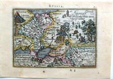 RUSSIA RUSSIAE MOSCOUIA c1590 BY ABRAHAM ORTELIUS GENUINE ORIGINAL ENGRAVED MAP
-
$395.00
 1588 Abraham Ortelius Map of Mexico - Hispaniae Novae - Nueva Espana
-
$125.00
 Mughal Empire India Ganges & Indus Rivers 1599 Ruscelli Rosaccio Ptolemy map
-
$302.50
 1574 Braun & Hogenberg Antique Map City Views of Rouen, Nimes & Bordeaux France


