 Antiques (US)
Africa Maps
Asia Maps
Australia/Oceania Maps
Celestial Maps
Central America/Caribbean Maps
Curiosities Maps
Digital Maps
Europe Maps
Map & Globe Mixed Lots
Map & Globe Reproductions
North America Maps
South America Maps
World & Celestial Globes
World Maps

-
$250.43

 Antique 1801? FOLDING MAP ON A CLOTH A NEW MAP OF MIDDLESEX JOHN CARY
-
$250.75
 Salem Marblehead Peabody Danvers 1897 lg. folding map Essex County Mass.
-
$125.22
 Australian States Original 1873 Map Folio (6) Chapman And Hall +New Zealand
-
$142.21
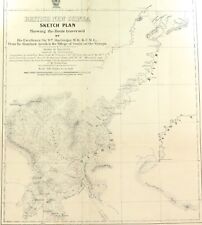
 RARE 1892 Colonial British New Guinea Large Map of The Gulf of Papua. #2
-
$295.00
 1890 CR Boyd Huge Color Folding Map of Washington County Virginia Topo Geologic
-
$29.95
 Original Antique New York State Rivers & Lakes Catchment Basins Map 1898
-
$99.99
 Hand Map ~ County of Moravia ~ Duchy of Silesia ~ Circa. 1888
-
$29.55
 1892 Antique Map Coshocton & Holmes Counties Ohio Millersburg New Castle Chili
-
$187.82
 Durham & Northumberland Large John Cary Maps, 1821 Census, Town Distances
-
$13.99
 Map 1877 KIELPINO GORNE-No.1775-Gdansk County-Pomerania-West Prussia-Poland
-
$4995.00
 Antique 1800s Maine Map Eastern Steamship Company Boothbay Division Sagadahoc
-
$900.00
 1825 - Map of UK Canals Situated in Counties of Lancaster York, Derby & Chester
-
$19.00
 1898, Washington, Spokane, Idaho, Kootenai County, USGS Survey Map, towns, river
-
$142.21
 RARE 1896 Colonial British New Guinea Map. Mambare River & Kumusi Valley
-
$142.21
 RARE 1894 Colonial British New Guinea Large Map of Collingwood Bay & Cape Nelson
-
$142.21
 RARE 1883 Colonial British New Guinea Map. Areas East of Port Moresby
-
$58.28
 JAMES WYLD WYLD’s ANTIQUE CLOTH MAP OF STAFFORD 1891 19th CENTURY SCARCE
-
$626.08
 Colton’s Traveler’s Map of the United States (1864)
-
$1450.00
 1804 Original Map of the State of New York Simeon DeWitt
-
$68.95
 1869 antique CHENANGO COUNTY ny MAP and TITLE PAGE mower knives oroide watch ads
-
$50.07
 Walker's DEVONSHIRE, antique folding map, J & C Walker circa 1840s, Devon
-
$13.99
 Map 1877 ROLBIK-No.2071-Rollbick-Brusy-Chojnice-Pomerania-Poland-German Empire
-
$13.99
 Map 1898 GRUDZIAZ-No.2578-Graudenz-Kuyavia Pomerania-Poland-Vistula-Marzy Stare
-
$13.99
 Map 1876 KARPNO-No.2070-Ostrowice-Drawsko-West Pomerania-Poland-German Empire
-
$99.00
 c1900 Walker Lithograph Co Map Of BOSTON MA Downtown area 33x27
-
$13.99
 Map 1874 LESNO-No.2072-Lésno-Brusy-Chojnice-Pomerania-Poland-German Empire
-
$15.00
 A 1900s Nelson County Nd. Plat Book cloth pages,maps, North Dakota townships
-
$99.95
 1890 Rand McNally & Co Oklahoma Indian Territory Antique Map Chicago
-
$142.21
 RARE 1896 Colonial British New Guinea Large Map. Mambare River to Gosisi Village
-
$95.00
 Chicago Antique 1895 Original Edgebrook SUB Map In Chicago TOTALLY AMAZING REPRO
-
$3575.00
 Tokugawa Period 徳川幕府 Very Large Antique Map of Shinano Province 信濃国 - Nagano 長野県
-
$241.82
 1880 Hardesty, Sectional & Township map of Ohio, very large 24 inch
-
$939.11
 1830 Map of the County Palatine of Lancaster Lancashire HENNET 162x115cm 64"x45"
-
$100.00
 TRAVEL GUIDE TO JAPAN Japanese Woodblock Print Map 1.47M Long 1848 Edo b536
-
$25.04
 19th Century Map of Northamptonshire Edward Stanford HAND COLOURED Ordnance
-
$29.50
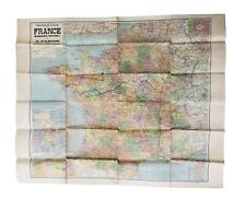 Nouvelle Carte De France Taride Map for Automobiles Bicycles 40-3/4" X 33-3/4"
-
$49.95
 Antique 1767 Map of MANOR RENSELAERWICK , Plot List, 1850 Print
-
$18.78
 Bacon's Leeds York and East Riding Half Inch Road Map antique 70 x 100 cms
-
$68.87
 SURREY C.W. Deacon original antique railway map c1880
-
$103.25
 RARE 1894 Colonial British New Guinea Map of Tauwara or Milne Bay
-
$12.51
 19thC Surrey Antique County Map Cruchley Gall & Inglis Cyclist Tourist Railways
-
$13.99
 Map 1875 KALISZ-No.1972-Kalisch-Dziemiany-Kościerzyna-Pomerania-Poland-WWII
-
$123.96
 OS Maps Robert Dawson Collection of County Maps
-
$75.00
 New Hampshire 1895 Rand-McNally Vest Pocket Folding Map Counties Cities Towns
-
$25.03
 1897 North Riding Yorkshire Antique Map Dales Railway Hawes 118x71cm Bartholomew
-
$250.43
 c1820 MAP Cornwall From a recent Survey With the Railways SCARCE ORIGINAL Linen
-
$32.00
 Original Antique 1886 COLOR MAP of CANADA Large Vintage History of Canada
-
$31.96
 New York Erie County Map Concord Township c1866 W12#10
-
$206.60
 1810 MAP Ordnance Survey of the Isle of Wight And part of Hampshire LARGE FORMAT
-
$13.99
 Map 1877 ROZLAZINO-No.1473-Wejherowo-Pomerania-Poland-Baltic Sea-1:25000
-
$20.00
 1859 Antique Color MITCHELL Map ~ US MIDDLE STATES ~ Original ~ Very Rare
-
$119.99
 VINTAGE 1885 PA GEOLOGICAL SURVEY REPORT HARD BOOK ELK FOREST CAMERON COUNTY MAP
-
$751.29
 1874 V. Large MAP North of England With County of Durham 146cm x 131cm SCARCE
-
$50.07
 1840s Nottinghamshire County Folding Map. Pub By H G Collins. Original Colour.
-
$13.99
 Map 1874 BRUSY-No.2172-Bruß-Chojnice-Pomerania-German Empire-Poland
-
$45.00
 1800s Devonshire England 1895 Antique County Map 10 x 12.5"
-
$12.51
 Late 19thC Victorian Surrey Sussex Antique Folding Map Brighton Chain Pier Smith
-
$14.85
 Philips' County Map of Devonshire c1895 Colour Folding Sheet, Ordnance Survey
-
$45.00
 1800's Dorsetshire England 1895 Antique County Map 10 x 12.5"
-
$2.49
 1898, Antique Map Aurillac, France, Ministere De L'Interrieur, Hatchette & Co
-
$25.04
 c1880 Bacon's County Guide and Map of Cheshire - Coloured Cloth
-
$50.07
 1840s Staffordshire County Folding Map. Pub by H G Collins. Original Colour
-
$56.35
 Antique Map "Buckinghamshire" J & C Walker, 1845
-
$219.13
 c1850 Wyld Kent Reduced Ordnance Survey Faden Mudge Large 96x65cms Antique Map
-
$13.99
 Map 1876 MALACHIN-No.2173-Chojnice-Czersk-Pomerania-German Empire-Poland
-
$59.99
 1887 HAND-COLORED FRANKLIN COUNTY KANSAS MAP Large fold-out with many PLATS
-
$35.00
 MA. ATLAS Plate #14 Bristol, Plymouth, North Attleboroug Geo.H.Walker Co. 1900
-
$48.00
 THE ORANGES NEW JERSEY ESSEX COUNTY 1889 LARGE ANTIQUE REPRO. MAP BADWIN
-
$144.00
 c1830 MAP Somersetshire Divided into Hundreds &c and the Parliamentary Divisions
-
$52.59
 Bacon's Map of North Wales From Ordnance Surveys Names of Railway Stations 1890
-
$7.96
 Wisconsin Sheboygan or Manitowoc 1876 Single Special Price! L14#72
-
$45.00
 1800 Denbigh and Flint 1895 Antique County Map 10x12.5"
-
$13.99
 Map 1898 SARTOWICE-No.2577-Sartowitz-Swiecie-Kuyavia Pomerania-Poland-Czapelki
-
$112.68
 1804 (1825) Antique Folding Map; Monmouthshire. Charles Smith. Excellent Example
-
$181.56
 Antique Map "Carta Corografica della divisione di Novara" G.Battista Maggi, 1852
-
$7.96
 Wisconsin Dunn or Pierce County Single 1876 Special Price L14#89
-
$62.61
 Antique Map "Huntingdonshire" J & C Walker, 1846
-
$23.96
 Pennsylvania Lebanon County Map North Lebanon 1875 Double Side W15#44
-
$7.96
 Pennsylvania Lebanon County Map 1st Reformed Church & Tabor Chapel 1875 W15#52
-
$45.00
 1800s Cumberland England 1895 Antique County Map of 10x12.5"
-
$7.96
 Pennsylvania Lebanon County Map Res. & Sale Exchange Jacob Baney 1875 W15#56
-
$41.32
 Bacon’s New Tourist Map of South Wales Names of Railway Stations ca1890
-
$56.35
 100% ORIGINAL MIDLAND COUNTIES FOLDING MAP LINEN BY CRUCHLEY C1870/ VGC COLOUR
-
$50.00
 1800s Derbyshire England 1895 Antique County Map 10x12.5"
-
$15.96
 New York Erie County Map Farnham Station Lower Ebenezer Mill Port c1866 W11#91
-
$7.96
 Wisconsin Chippewa County or Chippewa Falls 1877 Single Pg Special Price! L14#52
-
$23.96
 California Tulare County Map Bravo Lake Township 17 Dbl Sd 1892 !W12#72
-
$50.02
 Antique Folding Map, Walker, J & C, Northamptonshire c1840
-
$31.96
 New York Erie County Map Wales Township c1866 W11#94
-
$25.00
 Original Antique 1886 Large COLOR MAP of QUEBEC, CANADA ~ Great Detail * Rare
-
$62.61
 Antique Map "Northamptonshire" J & C Walker, 1835
-
$62.61
 Antique Map "Worcestershire" J & C Walker, 1846
-
$112.68
 1804 (1827) Antique Folding Map; Lancashire. Charles Smith - Excellent
-
$25.00
 Original Antique 1886 Large COLOR MAP of ONTARIO, CANADA ~ Great Detail * Rare
-
$876.51
 Faden The Country Twenty-Five Miles Round London Slipcase Hand Coloured 1815
-
$7.96
 Wisconsin Chippewa County or Chippewa Falls 1877 Single Pg Special Price! L14#50
-
$49.99
 1887 HAND-COLORED ELDORADO PLAT MAP BUTLER COUNTY KANSAS Large Folding Map
-
$16.27
 Philips' County Map of Bedfordshire c1895 Colour Folding Sheet, Ordnance Survey
-
$129.22
 RARE 1899 Colonial Western Part British New Guinea Huge Folding Map.
-
$1199.00
 1854 STATE OF CONNECTICUT "LARGE 28"X23" POCKET MAP,NEW YORK,NEW JERSEY,ORIGINAL


