 Antiques (US)
Africa Maps
Asia Maps
Australia/Oceania Maps
Celestial Maps
Central America/Caribbean Maps
Curiosities Maps
Digital Maps
Europe Maps
Map & Globe Mixed Lots
Map & Globe Reproductions
North America Maps
South America Maps
World & Celestial Globes
World Maps

-
$298.00

 Antique Japan Map Photo-Litho 1899 Railroads Steamship Lines Coal Tea Oil Rice
-
$125.00
 Ambroise TARDIEU c1822 Map Venice Napoleon Italian Campaign 17" x 11"
-
$9.44
 Antique 1885 Map Early Voyages & Discoveries of North America 8x10
-
$32.56
 1880s Map Dorsetshire by J & C Walker Hand Coloured Parliamentary Divisions
-
$69.99
 Original Antique Map LAKE CHAMPLAIN 1732 Land-Grant Survey Chambly Crown Point
-
$75.00
 1888 Noll’s New Road, Driving, And Bicycle Map Of Philadelphia 34.5” x 21”
-
$1189.00
 1848 Phelps’s Travellers Guide through the United States & Map
-
$19.95
 Vintage 1927 Denoyer-Geppert Fold Out Map Presidential Elections 1864 to 1876
-
$69.00
 19th C. Map United States (West)-Texas- Engraved & Hand Color -Mackenzie 1867
-
$134.99
 Map FRONTIERS OF THE NORTHERN COLONIES + 1768 Fort Stanwix Treaty with Indians
-
$49.00
 19th C. Map Germany-Bavaria- Engraved & Hand Colored -William Mackenzie 1867
-
$49.00
 19th C. Map of United States(East)- Engraved Plate &Color -Mackenzie London 1867
-
$79.99
 Original MAP OF FRENCH & ENGLISH GRANTS ON LAKE CHAMPLAIN New York Vermont Pease
-
$21.37
 BI-FOLD MAP WEST PART LINVILLE CREEK MAGISTRIAL DISTRICT, VIRGINIA, D.J. LAKE &
-
$49.00
 19th C. Map Holland- Engraved & Hand Colored -William Mackenzie 1867
-
$59.00
 19th C. Map Australia- Engraved & Hand Colored -William Mackenzie 1867
-
$99.99
 Original 1849 Antique Map LAKE CHAMPLAIN ~ Chambly to Crown Point ~ Land Survey
-
$149.95
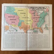 ~1899 The Chicago Daily News' Map Illustrating The Territorial Growth of the US
-
$49.00
 19th C. Map Denmark- Engraved & Hand Colored -William Mackenzie 1867
-
$125.00
 C. 1830s J.H. Goldthwait Foldout Color Map Book Of Massachusetts
-
$49.00
 19th C. Map Greece- Engraved & Hand Colored -William Mackenzie 1867
-
$49.00
 19th C. Map North America- Engraved Plate & Hand Color by Mackenzie London 1867
-
$49.00
 19th C. Map Sweden & Norway- Engraved & Hand Colored -William Mackenzie 1867
-
$49.00
 19th C. Map Russia & Poland- Engraved & Hand Colored -William Mackenzie 1867
-
$49.00
 19th C. Map Germany- Engraved & Hand Colored -William Mackenzie 1867
-
$59.00
 19th C. Map New Zealand- Engraved & Hand Colored -William Mackenzie 1867
-
$49.00
 19th C. Map Austria- Engraved & Hand Colored -William Mackenzie 1867
-
$49.00
 19th C. Map Spain & Portugal- Engraved & Hand Colored -William Mackenzie 1867
-
$49.00
 19th C. Map Turkey- Engraved & Hand Colored -William Mackenzie 1867
-
$49.00
 19th C. Map Prussia- Engraved & Hand Colored -William Mackenzie 1867
-
$18.52
 BI-FOLD MAP EAST PART OF ASHBY MAGISTRIAL DISTRICT,VIRGINIA, D. J. LAKE DO., 188
-
$49.00
 19th C. Map France - Engraved Plate & Hand Colored William Mackenzie London 1867
-
$49.00
 19th C.Map China- Engraved Plate & Hand Colored by William Mackenzie London 1867
-
$149.99
 Original 1864 Comstock & Cassidy New York Map + Agricultural Transactions Book
-
$49.00
 19th C. Map Italy - Engraved Plate & Hand Colored William Mackenzie London 1867
-
$2499.99
 Original 1863 Pocket Maps J. Calvin Smith NORTHEAST US & C.H.V. Cavis WHITE MTNS
-
$49.00
 19th C. Map Asia- Engraved Plate & Hand Colored by William Mackenzie London 1867
-
$49.00
 19th C.Map Italy #2 (Sicily) Engraved Plate & Hand Colored Mackenzie London 1867
-
$129.99
 1965 Mexican War & Territorial Adjustments 1846 Denoyer-Geppert Map WA20 44x38
-
$49.00
 19th C.Map India (South)- Engraved Plate & Hand Colored by Mackenzie London 1867
-
$49.00
 19th C.Map India (North)- Engraved Plate & Hand Colored by Mackenzie London 1867
-
$24.98
 1840 ORIGINAL MAP OF ENGLAND & WALES - GEORGE VIRTUE / BECKER - RAILWAYS
-
$49.00
 19th C.Map Ireland - Engraved Plate & Hand Colored William Mackenzie London 1867
-
$34.99
 Original 1830 Menzies Map SCOTLAND Edinburg Inverness Perth Aberdeen Loch Ness
-
$49.00
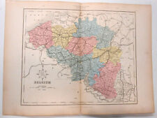 19th C.Map Belgium - Engraved Plate & Hand Colored William Mackenzie London 1867
-
$49.00
 19th C. Map Africa - Engraved Plate & Hand Colored William Mackenzie London 1867
-
$129.99
 1957 Westward Movement 1763-1829 Denoyer-Geppert Social Science Map A10 44x37
-
$49.00
 19th C. Map South America-Engraved & Hand Colored William Mackenzie London 1867
-
$1.25
 Antique map Holland & Belgium c1870 Collins Students Atlas good condition
-
$1999.99
 Original 1846 Tanner Pocket Map NEW ENGLAND Land Grants Canals Railroads Phyfe
-
$479.00
 1856 U.S. Coast Survey Map Central America, , Rare, Yucatan, Caribbean, Mexico
-
$85.00
 Denoyer Geppert Westward Move 1763-1829 & Colonial Com.1690-1744 pull down map
-
$17.52
 FOLDING SKETCH MAP BATTLE PLAN PENINSULAR WAR PORTUGAL NORTHERN PORTION 1808
-
$17.52
 ANTIQUE FOLDING MAP BATTLE PLAN PENINSULAR WAR SPAIN BATTLE OF VITTORIA 1813
-
$17.52
 FOLDING SKETCH MAP BATTLE PLAN PENINSULAR WAR PORTUGAL SOUTHERN PORTION 1808
-
$17.52
 ANTIQUE FOLDING MAP BATTLE PLAN PENINSULAR WAR SPAIN BATTLE OF ALBUHERA 1811
-
$17.52
 ANTIQUE FOLDING MAP BATTLE PLAN PENINSULAR WAR FRANCE NIVELLE ORTHES 1813-1814
-
$17.52
 FOLDING SKETCH MAP BATTLE PLAN BATTLE OF WATERLOO MARCH OF ARMIES 1815
-
$17.52
 ANTIQUE FOLDING MAP BATTLE PLAN PENINSULAR WAR SPAIN CAMPAIGN OF SALAMANCA 1812
-
$17.52
 ANTIQUE FOLDING MAP BATTLE PLAN PENINSULAR WAR FRANCE BATTLE OF TOULOUSE 1814
-
$17.52
 ANTIQUE FOLDING MAP BATTLE PLAN PENINSULAR WAR SPAIN SIEGE OF CIUDAD RODRIGO1812
-
$93.91
 Original antique 1845 map of North America with population by state
-
$17.52
 ANTIQUE FOLDING MAP BATTLE PLAN PENINSULAR WAR SPAIN BATTLE OF SALAMANCA 1812
-
$17.52
 ANTIQUE FOLDING MAP BATTLE PLAN PENINSULAR WAR FRANCE PASSAGE OF BIDASSOA 1814
-
$17.52
 ANTIQUE FOLDING MAP BATTLE PLAN PENINSULAR WAR FRANCE BATTLE OF ORTHES 1814
-
$50.07
 Europe: Cruchley's New Map of Europe with Political Divisions c.1860 MEDIUM


