 Antiques (US)
Africa Maps
Asia Maps
Australia/Oceania Maps
Celestial Maps
Central America/Caribbean Maps
Curiosities Maps
Digital Maps
Europe Maps
Map & Globe Mixed Lots
Map & Globe Reproductions
North America Maps
South America Maps
World & Celestial Globes
World Maps

-
$79.99

 1911 ATLAS COVER PAGE of WESTCHESTER COUNTY NEW YORK FROM ATLAS SURVEYS 22"x 17"
-
$28.00
 1912 South Carolina Map ORIGINAL Counties Population McClellanville Georgetown
-
$28.00
 CALIFORNIA Map 1912 ORIGINAL Counties Population Los Angeles San Diego Monterey
-
$37.88
 VERMONT Map 1912 ORIGINAL Counties Population Montpelier Sand Gate Vintage
-
$28.88
 VINTAGE MARYLAND Map 1912 ORIGINAL Counties Population Annapolis Baltimore
-
$14.50
 1912 Plat Map Itasca Township Clearwater County Minnesota Mallard Gill Lake
-
$28.88
 MINNESOTA Map 1912 ORIGINAL Counties Population Minneapolis St Paul Duluth
-
$19.50
 1914 Plat Map Village of Chatham Sangamon County Illinois
-
$28.88
 1916 Map Maine County Townships Railroads Portland Alfred Ellsworth Machias
-
$36.88
 1912 NORTH DAKOTA Map ORIGINAL Counties Population Bismarck Boundary VINTAGE
-
$28.88
 TENNESSEE Map 1912 ORIGINAL Counties Population Hill's Landseekers Atlas VINTAGE
-
$14.50
 1912 Plat Map Part of White Earth Indian Reservation Clearwater County Minnesota
-
$28.88
 ORIGINAL 1912 MISSISSIPPI Map Counties Populations Gulf Vicksburg Natchez
-
$28.88
 VINTAGE NEW YORK Map 1912 ORIGINAL Counties Long Island Buffalo Troy Albany
-
$14.00
 1915 Plat Map Holt County, Nebraska, Twsp 25-10 Lake & Deloit precincts Ancestry
-
$14.00
 1915 Plat Map Holt County, Nebraska Twsp 25-11 Lake precinct Ancestry
-
$14.50
 1912 Plat Map Leon Township Clearwater County Minnesota Beard Clearbrook
-
$24.50
 1914 Plat Map Curran Township Sangamon County Illinois USGS Soil Map Rare
-
$14.50
 1912 Plat Map Part of White Earth Indian Reservation Clearwater County Minnesota
-
$14.50
 1912 Plat Map Town of Gonvick Pine Lake Township Clearwater County Minnesota
-
$14.50
 1912 Plat Map Town of Clearbrook Leon Township Clearwater County Minnesota
-
$14.50
 1912 Plat Map Part of White Earth Indian Reservation Clearwater County Minnesota
-
$24.50
 1914 Plat Map Divernon Township Sangamon County Illinois USGS Soil Map Rare
-
$14.50
 1912 Plat Map Holst Township Clearwater County Minnesota Lake peterson
-
$19.50
 1914 Plat Map Village of Loami Sangamon County Illinois
-
$14.50
 1912 Plat Map Town of Leonard Murray Ebro Clearwater County Minnesota
-
$45.95
 1916 Plat Map ~ LEE COUNTY, IOWA ~ Authentic Atlas Map ~ (14x17) Free S&H -#001
-
$24.50
 1914 Plat Map Springfield Township Sangamon County Illinois USGS Soil Map Rare
-
$10.86
 1911 Color County Map of Maryland and Delaware States
-
$60.00
 1910 Ohio Highway Map Ottawa County Lakeside Marblehead Port Clinton Oak Harbor
-
$14.00
 1915 Plat Map Holt County, Nebraska, Twsp 25-12 Conley precinct; Ancestry
-
$10.86
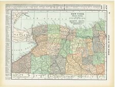 1910 Color County Map of Western & Upstate Section New York State
-
$28.50
 1914 Antique Color Map of Sangamon County Illinois
-
$14.50
 1912 Plat Map Eddy Township Clearwater County Minnesota 148N 38W
-
$14.50
 1912 Plat Map Bear Creek Township Clearwater County Minnesota Alida
-
$24.50
 1914 Plat Map Cotton Hill Township Sangamon County Illinois USGS Soil Map Rare
-
$14.50
 1912 Plat Map Part of Red Lake Indian Reservation Clearwater County MN 150N 36W
-
$14.50
 1912 Plat Map Pine Lake Township Clearwater County Minnesota Gonvick
-
$10.86
 1911/12 Color County Map of North & South Carolina States
-
$10.86
 1910 Color County Map State of Wisconsin and Missouri
-
$14.50
 1912 Plat Map Greenwood Township Clearwater County Minnesota Red Lake Indian res
-
$14.50
 1912 Plat Map Part of White Earth Indian Reservation Clearwater County Minnesota
-
$45.95
 1916 Plat Map WEST POINT Twp., LEE Co., IOWA / FRANKLIN Twp. on Reverse (14x17)
-
$45.95
 1916 Plat Map MADISON Twp., LEE Co., IOWA / HARISON Twp. on Reverse (14x17)
-
$14.50
 1912 Plat Map Minerva Township Clearwater County Minnesota Upper Rice Lake
-
$14.50
 1912 Plat Map Sinclair Township Clearwater County Minnesota 149N 36W
-
$14.50
 1912 Plat Map Winsor Township Clearwater County Minnesota
-
$14.50
 1912 Map Northern Portion of Clearwater County Minnesota Red Lake Indian Reserve
-
$14.50
 1912 Plat Map State Park Clearwater County Minnesota Lake Itasca Elk Lake
-
$14.50
 1912 Plat Map Hangaard Township Clearwater County Minnesota Red Lake Indian Res
-
$14.50
 1912 Plat Map Copley Township Clearwater County Minnesota Bagley Red Lake Road
-
$14.50
 1912 Plat Map Dudley Township Clearwater County Minnesota Four Legged
-
$24.50
 1914 Plat Map Clear Lake Township Sangamon County Illinois USGS Soil Map Rare
-
$19.50
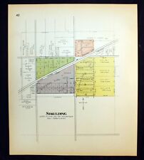 1914 Plat Map Village of Spaulding Sangamon County Illinois Clear Lake Township
-
$12.50
 1912 Plat Map Part of Red Lake Indian Reservation Clearwater County MN 152N 38W
-
$12.50
 1912 Plat Map Part of Red Lake Indian Reservation Clearwater County MN 151N 36W
-
$12.50
 1912 Plat Map Part of Red Lake Indian Reservation Clearwater County MN 152N 36W
-
$12.50
 1912 Plat Map Part of Red Lake Indian Reservation Clearwater County MN 152N 37W
-
$12.50
 1912 Plat Map Part of Red Lake Indian Reservation Clearwater County MN 151N 37W
-
$14.50
 1912 Map Southern Portion of Clearwater County Minnesota White Earth Indian res
-
$19.50
 1914 Plat Map Village of Buffalo Sangamon County Illinois Mechanicsburg Township
-
$14.50
 1912 Plat Map Part of White Earth Indian Res Clearwater County Minnesota
-
$14.50
 1912 Plat Map Moose Creek Township Clearwater County Minnesota
-
$14.50
 1912 Plat Map Shevlin Township Clearwater County Minnesota Red Lake res line
-
$6.50
 Map: Vermont & New Hampshire - 1910 county boundaries, railways, cities - sepia
-
$19.50
 1914 Plat Map Villages of Curran Glenarm Cantrall Sherman Sangamon County IL
-
$24.50
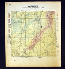 1914 Plat Map Auburn Township Sangamon County Illinois USGS Soil Map Rare
-
$14.50
 1912 Plat Map Popple Township Clearwater County Minnesota Elected Officials
-
$19.50
 1914 Plat Map Village of Mechanicsburg Sangamon County Illinois
-
$14.50
 1912 Plat Map Nora Township Clearwater County Minnesota Mud Lake
-
$29.50
 1914 Plat Map Buffalo Hart Township Sangamon County Illinois USGS Soil Map Rare
-
$19.50
 1914 Plat Map Village of Williamsville & Barclay Sangamon County Illinois
-
$19.50
 1914 Plat Map Village of Divernon Sangamon County Illinois
-
$19.50
 1914 Plat Map Villages of Breckenridge Rochester Berry Sangamon County Illinois
-
$24.50
 1914 Plat Map Gardner Township Sangamon County Illinois USGS Soil Map Rare
-
$24.50
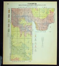 1914 Plat Map Cooper Township Sangamon County Illinois USGS Soil Map Rare
-
$24.50
 1914 Plat Map Fancy Creek Township Sangamon County Illinois USGS Soil Map Rare
-
$24.50
 1914 Plat Map Village of Riverton Sangamon County Illinois Clear Lake Township
-
$24.50
 1914 Plat Map Loami Township Sangamon County Illinois USGS Soil Map Rare
-
$24.50
 1914 Plat Map Woodside Township Sangamon County Illinois USGS Soil Map Rare
-
$24.50
 1914 Plat Map Talkington Township Sangamon County Illinois USGS Soil Map Rare
-
$24.50
 1914 Plat Map Salisbury Township Village Sangamon County Illinois USGS Soil Rare
-
$24.50
 1914 Plat Map Maxwell Township Sangamon County Illinois USGS Soil Map Rare
-
$24.50
 1914 Plat Map Williams Township Sangamon County Illinois USGS Soil Map Rare
-
$24.50
 1914 Plat Map Chatham Township Sangamon County Illinois USGS Soil Map Rare
-
$24.50
 1914 Plat Map Ball Township Sangamon County Illinois USGS Soil Map Rare
-
$6.00
 Map: Missouri - 1910 county boundaries, railways, cities, St. Louis inset - B&W
-
$45.95
 1916 Plat Map ~ GREEN BAY Township - LEE County, IOWA (14x17) Free S&H -#010
-
$24.50
 1914 Plat Map Rochester Township Sangamon County Illinois USGS Soil Map Rare
-
$32.50
 1914 Plat Map Cartwright Township Sangamon County Illinois USGS Soil Map Rare
-
$45.95
 1916 Plat Map ~ PLEASANT RIDGE Township LEE County, IOWA (14x17) Free S&H -#008
-
$22.50
 1914 Plat Map Villages of Auburn Lowder Thayer Sangamon County Illinois
-
$45.95
 1916 Plat Map MARION Twp., LEE Co., IOWA / CEDAR Twp. on Reverse (14x17)
-
$27.99
 1910 Ohio Highway Map Sandusky County Fremont Ballville Woodville Clyde Lindsey
-
$131.74
 Antique Caricature Map "Russia" Lilian Lancaster Tennant, 1912
-
$144.29
 Antique CaricatureMap "Iceland" Lilian Lancaster Tennant, 1912
-
$138.02
 Antique Caricature Map "Ireland" Lilian Lancaster Tennant, 1912
-
$45.95
 1916 Plat Map ~ JACKSON Twp., LEE County, IOWA (XL17x28) ~ St PAUL, MARION Twp.
-
$10.86
 1911 Color County Map State of Minnesota
-
$13.86
 1912 Color County Maps of West & Eastern Texas (Double page) and Oklahoma States


