 Antiques (US)
Africa Maps
Asia Maps
Australia/Oceania Maps
Celestial Maps
Central America/Caribbean Maps
Curiosities Maps
Digital Maps
Europe Maps
Map & Globe Mixed Lots
Map & Globe Reproductions
North America Maps
South America Maps
World & Celestial Globes
World Maps

-
$48.88

 1956 Map Louisiana LARGE ORIGINAL New Orleans Lafayette Baton Rouge Railroads
-
$57.88
 VINTAGE 1956 Mexico Map ORIGINAL Central America Baja RAILROADS United States
-
$57.88
 1956 Norway Sweden Finland Map Soviet Union Germany Poland Iceland Leningrad
-
$695.00
 Original Lake Wallenpaupack Area Map Hand Drawn Property Map From 1950
-
$24.99
 Map of Alexandria, VA circa 1950's
-
$19.99
 Vintage 1956 Original Kentucky Map US Dept Of Interior 30x15
-
$74.99
 Vintage Lighted Constellation Globe Stars Map Celestial Light Up Greek Mythology
-
$19.99
 1952 Rand McNally Missouri Pocket Map Highly Detailed Mapping Vintage Ex Cond!
-
$20.25
 1950s Vintage Oregon State Map Animated Oregon Picture Map BW 1091
-
$23.45
 1951 Metropolitan New Jersey New York Highways Port Authority Holland Tunnel
-
$25.00
 Vintage The Kroll Map of Alaska - Rare - 36" X 43" very nice unused condition
-
$19.99
 Book Enterprises 3 Maps-Solar System & Outer Space Universal World Map USA 1959
-
$14.99
 1959 USAF Jet Navigation Map Flight Chart Southwest Los Angeles Denver Las Vegas
-
$57.00
 PHILIPPINES SOUTHEAST ASIA 1956 MAP Original Borneo Manila Celebes Sumatra
-
$56.88
 1956 Map Brazil Colombia Panama Venezuela Medellin Caracas Quito Ecuador
-
$67.88
 1953 India Map Pakistan Punjab Nepal Ceylon Bhutan Himalayan Mountains Kashmir
-
$34.50
 vintage 8” REPLOGLE Standard WORLD GLOBE Made in Chicago, ILL
-
$37.88
 1956 Virginia Map Norfolk Richmond Appomattox Radford Chesapeake Bay Hampton
-
$27.99
 1958 Becvar Star Map II North Sky Andromeda Perseus Astronomy Chart Telescope
-
$12.89
 Geologic Map: Klein Branch Quadrangle, Texas
-
$7.25
 DILLON, MONTANA AREA CONTOUR MAP, 1955, Includes National Forrest Land
-
$30.00
 BIG Vtg. 1957 Map "Landforms of the United States" Erwin Raisz 41.5"Wx27"H
-
$9.45
 Preu MICHELIN Map 140 Carte Touristique de la PROVENCE 1950's France
-
$19.98
 1959 US Northwest Jet Navigation Map Flight Chart Mlps San Francisco Seattle
-
$1500.00
 American Printing House for the Blind Globe 1959 Rare Vintage Braille APH
-
$55.00
 1951 City Map Of Central Tokyo
-
$17.95
 Rand McNally Readers WORLD ATLAS Book Old Maps 1955 Vintage
-
$34.00
 Vintage 1950s Ohio Art Tin Litho World Globe 9" Dia x 11" Tall No Dents
-
$68.88
 1956 South America Map Bolivia Paraguay Argentina Peru Brazil Chile Potosi
-
$67.00
 1956 Germany Map Czechoslovakia Mannheim Leipzig Dresden Stuttgart Prague
-
$67.88
 1956 Vancouver British Columbia Map Canada Penticton Vernon Kamloops Nelson
-
$57.00
 1956 MAP INDIA PAKISTAN BURMA TIBET Nepal Bhutan Afghanistan Persia Ceylon
-
$25.00
 Vintage Hammond International Map Of The World 50” X 33" Ship & Air Routes 1957
-
$20.25
 1950s Vintage California State Map Animated California Picture Map BW 1287
-
$2.99
 Rare 1954 Map of Milwaukee County, Milw. County Department of PublicWorks
-
$9.95
 Vintage Map of ENGLAND Wall Art Railroad Decor Original 1950s Railway London
-
$14.00
 VINTAGE MAP 1951 DRAFT OUTLOOK FOR STUDENTS KOREAN WAR GREAT GRAPHICS 48” X 35”
-
$49.99
 1950s Guam Booklets Brochures Cold War Post War Map Military Marinaras
-
$66.00
 1956 Minnesota Map ORIGINAL Minneapolis St Paul County Townships Railroads
-
$57.00
 1956 Europe Map Topographical Elevations France Turkey Asia Yugoslavia Germany
-
$20.00
 1950s Map Greenwich Village New York Street Map Apartment Ad Christopher Street
-
$80.00
 Replogle Starlight 1950 Terrestrial Black Water 12" Globe
-
$39.95
 1955 London TIMES ATLAS OF THE WORLD Vol.III Northern Europe - Germany, France..
-
$57.00
 1956 Iowa Map Dubuque Des Moines Davenport Council Bluffs Cedar Rapids Dodge
-
$57.00
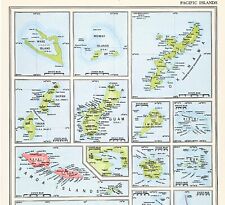 1956 Pacific Islands Map Fiji Guam Samoa Okinawa Iwo Bikini Palau Tinian
-
$15.00
 Vintage Seaboard Air Line Railroad Map 1959 Freight Traffic Department 27 x 21
-
$99.99
 1957 PRESERVATION SOCIETY THIS IS NEWPORT RHODE ISLAND! MAP PRINT NEWPORT COUNTY
-
$1750.00
 VINTAGE 1952-54 DENOYER-GEPPERT 12 LARGE 43" X 32-43" PULL DOWN SCHOOL MAPS
-
$39.95
 1956 London TIMES ATLAS OF THE WORLD Vol. IV Southern Europe & Africa Spain Etc
-
$19.95
 Hagstroms Map Of Queens New York 1950's Subways, Elevated Surface Lines
-
$10.00
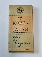 Vintage map of JAPAN and KOREA 1950s- MSTS Department of The Navy MILITARY Sea
-
$57.00
 1956 Nova Scotia Map New Brunswick Prince Edward Halifax Cape Breton Island
-
$37.88
 1953 Washington Map ORIGINAL Seattle Tacoma Puget Sound Olympia Port Angeles
-
$47.88
 1956 Ontario Canada Map ORIGINAL Toronto Great Lakes Railroads Townships
-
$20.25
 1950s Vintage Michigan State Map Animated Michigan Picture Map Decor BW 1105
-
$47.88
 1956 Switzerland Map Germany Italy Austria France Zurich Brescia Innsbruck
-
$57.00
 1956 Map WISCONSIN Milwaukee Green Bay Appleton Madison Eau Claire Lake Superior
-
$57.88
 1953 Kentucky Tennessee Map Knoxville Lexington Nashville Memphis Louisville
-
$57.00
 1956 ARCTIC REGION NORTH POLE MAP Original Alaska Siberia Greenland Canada
-
$34.95
 Vintage MCM Miniature Desk Top Brass Stand Olde World Globe Made in Italy
-
$47.00
 VINTAGE MAP 1953 Wyoming ORIGINAL Yellowstone Laramie Cheyenne Big Horn Railroad
-
$57.00
 1956 Australia Map Melbourne Sydney Adelaide Brisbane Rockhampton Newcastle
-
$37.99
 Hammond's International wall Map of World 1950s Mercators Projection 33x50
-
$11.99
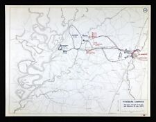 West Point Civil War Map Battle Jackson Vicksburg Mississippi Sherman July 10
-
$57.88
 1956 MIDDLE EAST Iran Afghanistan MAP Tehran Kabul Pakistan Iraq Bahrain Qatar
-
$57.88
 1953 West Virginia Map ORIGINAL Richmond Huntington Lynchburg Newport News
-
$57.88
 VINTAGE MAP 1956 CANADA ELEVATIONS ALTITUDES HUDSON BAY BRITISH COLUMBIA
-
$57.88
 KANSAS 1953 MAP ORIGINAL Topeka Overland Wichita Lawrence Olathe Dodge City
-
$14.99
 Color Map Algerian Highway System July 1957 -- First Helicopter War 1954-1962
-
$57.00
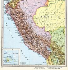 1956 South America Map Peru Brazil Colombia Ecuador Chile Andes Amazon
-
$57.00
 1956 France Map Paris Normandy Toulon Marseille Grenoble Lyon Champagne Rouen
-
$57.00
 1953 NEW JERSEY Map Elizabeth Egg Harbor Sussex Cape May Woodbridge Howell
-
$57.88
 1953 Oregon Map Bend Portland Eugene Medford Salem Hillsboro Mount Hood Klamath
-
$57.88
 1953 Europe Map Italy Germany Prussia England Russia Crimea Spain Paris London
-
$56.88
 VINTAGE Denmark Germany Sweden Map ORIGINAL Europe Berlin Hamburg Copenhagen
-
$12.89
 Geologic Map: Dry Branch Quadrangle, Texas
-
$12.99
 THE PHILIPPINES - 1950s Country Map
-
$57.88
 1953 Mexico Map Chihuahua Vera Cruz Jalapa Campeche Chiapas Nayarit Juarez
-
$53.00
 1956 SOUTH CAROLINA MAP Columbia Charleston Greenville ORIGINAL Railroads
-
$5.99
 Hammonds Comparative World Atlas ; 1956 New Desk Edition
-
$43.00
 1953 Montana Map Missoula Billings Great Falls Helena Bozeman Yellowstone Custer
-
$9.99
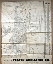 1950 Street Wall Map of Salem OR Compliments of Yeager Appliance Co.
-
$15.80
 VINTAGE CHEIN & CO. 9" WORLD METAL GLOBE CIRCA 1950`S USA W/ PLANETS BASE
-
$48.88
 1956 Maryland Map Washington DC Baltimore Annapolis Wilmington Easton Cambridge
-
$100.00
 Mid-Century Vintage Weber Costello Contour Relief Tru-Vue Globe Lucite Topo NICE
-
$7.50
 USGS Topography Map Quadrangle Rawlins, Wyoming; CO 1954 Rev 1962 1:250,000
-
$12.00
 Vintage 1952 Tourist Map STOCKHOLM SWEDEN b&w photos
-
$87.50
 MANHATTAN NYC MAP 1664 DUKE'S PLAN FINE LITHOGRAPH HAND-DRAWN 1957 FULL COLOR
-
$28.30
 1951 ORIGINAL VINTAGE MAP OF MANHATTAN MIDTOWN AREA THEATERS NEW YORK CITY
-
$20.68
 1959 Picture / Pictorial Map Geography of ARIZONA by PS JOHST - VERNON QUINN
-
$19.99
 Large-Format 1955 GEOLOGIC MAP CANAL ZONE & ADJOINING PARTS OF PANAMA Woodring
-
$25.95
 1953 Roads to Romance Southern California Old Map - 24x36
-
$18.00
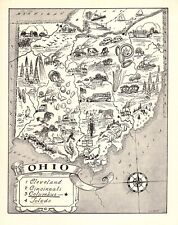 1950s Vintage Ohio State Map Animated Ohio Picture Map Wall Decor BW 1281
-
$20.25
 1950s Vintage Montana State Map Animated Montana Picture Map Wall Decor BW 1095
-
$16.16
 1950s Vintage Georgia State Map Vintage Animated Map of Georgia Picture Map 1434
-
$15.00
 Large Geologic Map & Sections Fort Defiance Tohatch Quadrangles AZ NM 1953
-
$18.50
 vintage lot 1955 MAP / brochures Germany: Baden-Wurttemberg, Bavaria, Stuttgart
-
$14.40
 Soviet Finnish War Map Battle of Suomussalmi Russia Finland Dec Jan 1939-40
-
$156.13
 VINTAGE W AK JOHNSTON 1950s SCHOOL EDUCATIONAL ENGLAND & WALES COUNTIES WALL MAP
-
$500.00
 denoyer geppert globe 1954 antique globe on stand (RARE) antique globe on stand


