 Antiques (US)
Africa Maps
Asia Maps
Australia/Oceania Maps
Celestial Maps
Central America/Caribbean Maps
Curiosities Maps
Digital Maps
Europe Maps
Map & Globe Mixed Lots
Map & Globe Reproductions
North America Maps
South America Maps
World & Celestial Globes
World Maps

-
$40.00

 Palestine Map Before Nakba 1948 Atlas Maps خريطة فلسطين قبل النكبة خرائط اطلس
-
$149.99
 Antique Standard Atlas Ford County, Kansas, 1905-06
-
$170.00
 an atlas of ancient geography by samuel butler 1844
-
$40.00
 Palestine Map Before Nakba 1948 Atlas Maps خريطة فلسطين قبل النكبة خرائط اطلس
-
$35.00
 1873 GUYOT'S PHYSICAL GEOGRAPHY World Maps Atlas History
-
$199.99
 La Salle County Illinois Antique ATLAS & Plat Book Hand Colored Maps 1929
-
$69.95
 peerless atlas of the world 1898 1899 LARGE MAPS
-
$119.00
 San Diego County Aerial Foto Map Book 1984 1985 Photo Atlas Encinitas Del Mar
-
$45.00
 1876 Illinois Atlas 1972 Re Print
-
$84.95
 Combined Atlas 1871 1894 1913 Stephenson County Illinois IL Plat Book
-
$22.98
 Hammond’s New Era Atlas of the World 13.5” by 10” Colorful
-
$49.99
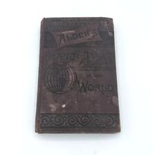 Antique 1889 Alden's Handy Atlas Of The World State Color Maps Pocket Book HC
-
$25.00
 USGS 1909 Belle Fourche Folio 164 South Dakota Black Hills Field Edition Atlas
-
$106.25
 geographical chronological and historical atlas by john blake 1826
-
$425.00
 Original Map Of The Azores By Abraham Ortelius, 1573
-
$106.25
 mitchell’s new school atlas 1867
-
$49.99
 Atlas of Peoria County, Illinois 1873 By A. T. Andreas
-
$9.95
 1874 G.M. HOPKINS ATLAS OF CITY OF SALEM, MASSACHUSETTS-MAP OF SALEM, PLATE G
-
$29.98
 The New Encyclopedic Atlas and Gazetteer of the World 1919 Edition
-
$39.00
 Set Of 4 DeLorme Atlas & Gazetters Maryland Pennsylvania Virginia West Virginia
-
$250.00
 1894 Plat Book Atlas of Clinton County Iowa Huebinger
-
$22.00
 Atlas of the World at War 1942 Vintage Maps
-
$22.00
 3 Original Vintage Maps of San Francisco
-
$20.00
 Rare 1853 Map ~ TURKEY & GREECE, CANDIA - IONIAN ISLANDS ~ (9.5x12) -#1597
-
$24.95
 Land Atlas & Plat Book MADISON COUNTY ILLINOIS 2015 Collinsville Granite City ++
-
$1995.00
 Antique 1873 Long Island New York Pocket Map J.B. Beers & Co. 54”x15” RARE
-
$39.99
 1876 Beers Somerset County Atlas Pennsylvania PA 1994 Ltd Printing Repro New
-
$30.00
 Hagstrom Litchfield County atlas
-
$155.00
 Antique MAP - NICKERSON, AURORA, BARCLAY, ARVONIA & PENFIELD - 1887 KANSAS ATLAS
-
$1199.99
 Vintage 1875 Atlas Of Iowa
-
$149.99
 Antique 1917 Standard Atlas Of Smith County, Kansas
-
$135.00
 Egypt Map Maps Atlas Cairo 1980 خريطة مصر القاهرة خريطه الطرق خرائط خارطة
-
$17.95
 Rand McNally Readers WORLD ATLAS Book Old Maps 1955 Vintage
-
$19.00
 1921 Literary Digest Atlas of New Europe and The Far East
-
$3800.00
 Rare Complete 1854 Cowperthwait's New Universal Atlas Of The World: Super clean
-
$174.95
 Original 1920 Schuyler County Illinois IL Atlas by Kenyon Co Plat Book
-
$39.95
 1986 Historical Atlas Richland County WI Illustrated Taylor Publishing Co.- Good
-
$34.99
 Vintage Color Folio Geologic Atlases of the United States, 1894 - 1945 PICK ONE!
-
$100.00
 Large 1848 Map of North Africa / Morocco from Charles Knight and Co atlas.
-
$136.00
 Mitchell’s new school atlas 1868
-
$120.00
 1856 Cartee's Physical Atlas School of Physical Geography 13 Maps WW
-
$19.99
 Scott County Iowa Atlas & Directory Plat Map Booklet 1972 Davenport LeClaire Etc
-
$139.95
 Crams Commercial Atlas U.S, World, 1920's? -Oceans, RR, Postal Info 16"x22"
-
$30.00
 Map of Santa Clara, California April 1866 14" x 17" Santa Clara College, Streets
-
$39.95
 1956 London TIMES ATLAS OF THE WORLD Vol. IV Southern Europe & Africa Spain Etc
-
$39.95
 1955 London TIMES ATLAS OF THE WORLD Vol.III Northern Europe - Germany, France..
-
$20.00
 1861 Map ~ VENEZUELA - PERU ~ Original Johnson Atlas (14x18) -#1573
-
$59.95
 Antique 1912 Book: 'The Library Atlas of the World' Vol. II Foreign Countries
-
$9.99
 Hammond's Modern Atlas of the World 1938 Before WWII-- HOW THE WORLD HAS CHANGED
-
$19.50
 1914 Plat Map Village of Chatham Sangamon County Illinois
-
$5.99
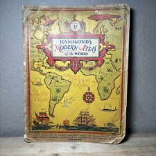
 Hammonds Comparative World Atlas ; 1956 New Desk Edition
-
$749.00
 1874 Illustrated Historical Atlas The State of Minnesota
-
$14.00
 GERMAN EMPIRE Antique Map Engraved 1885 - Fisk & Co. - Center Fold- Map XXVI
-
$224.99
 1874 ANTIQUE ONTARIO COUNTY NY ATLAS GENEVA CANANDAIGUA VICTOR PHELPS CLIFTON+
-
$75.99
 1873 Mitchell's Map Of North America Political Divisions Authentic Hand-colored
-
$59.99
 Vintage Atlas Plat Book Of COTTONWOOD County MN 1961 Thomas Nelson Minnesota
-
$8.99
 Vintage 2000 Millennium Edition Peoria County, Illinois Land Atlas/Plat Book
-
$200.00
 1916 Standard Atlas of Lafayette County Wisconsin Plat Book Ogle
-
$12.00
 *VINTAGE* Rand McNally 1974 International Atlas EUC
-
$1000.00
 RARE 1892 22" X 16" HUGE COMPLETE* Rand McNally Indexed Atlas Of The World
-
$76.50
 Bible atlas and gazetteer 1862
-
$20.00
 1853 Map ~ EASTERN PERSIA - KIRMAN, KHORASSAN, GREAT SALT DESERT (9.5x12) -#1584
-
$40.00
 1880 Atlas of Barnstable County Massachusetts Cape Cod's Earliest Atlas 1998 Ed.
-
$17.76
 1909 Vintage Map "Cleveland" or "Indiana" Color Map From Rand McNally Atlas
-
$221.95
 Original 1881 Wayne County Illinois IL Atlas by D J Lake & Co Plat Book
-
$67.50
 1894 USGS Geologic Atlas Pikes Peak Colorado Folio Cripple Creek Gold Field Ed
-
$15.24
 Vintage 1937 Two-Sided Color Map of Louisiana Kentucky Tennessee 11" x 14"
-
$20.00
 Rare 1853 Map ~ NORTHERN HEMISPHERE - ARCTIC, WORLD LAND MASS (9.5x12) -#1586
-
$85.00
 Ginn and Heath’s classical atlas 1879?
-
$32.50
 Firestone Road Atlas City Plans & Routes 1947 pictorial auto car travel book
-
$510.00
 Ewing’s new central atlas 1835??
-
$495.00
 Original Beers Atlas Oneida County New York 1874 Rome Utica
-
$199.95
 Original 1923 Boone County Illinois IL Atlas by Ogle & Co Plat Book
-
$60.00
 Map Tientsin, China 1913 Foreign Concessions, Imperialism, Drawn Crow's Handbook
-
$493.37
 AMERICA AMERICAE NOVI ORBIS c1590 BY ABRAHAM ORTELIUS GENUINE ORIGINAL MAP
-
$44.95
 Rare Rochester NY + Suburbs Large Planning District Map Book Atlas 1922 ?racist?
-
$127.50
 peerless atlas of the world 1903
-
$56.21
 Spain, set of 3 large antique maps 1831. S.D.U.K.
-
$19.99
 World Atlas Hammonds Historical Maps
-
$25.00
 Marysville California 1896 Geologic Atlas USGS Folio 4 Maps = Colusa Yuba City
-
$29.99
 1902 GEOLOGIC ATLAS OF THE US ATOKA FOLIO INDIAN TERRITORY MAPS TOPOGRAPHY
-
$40.00
 Antique Colliers World Atlas & Gazetteer - 1936 Edition- Oversized. See Pictures
-
$9.75
 1910 Antique Color Map of The World 17" x 27"
-
$19.98
 CAPPER'S 1935 (Pre-WW2) ATLAS OF THE WORLD by Lloyd E. Smith RARE
-
$30.00
 Peoples Atlas Of The World 1894 Published by Mast Crowell Kirkpatrick Antique
-
$20.00
 Rare 1853 Map ~ GRECE & THE IONIN ISLANDS, MOREA - LIVADIA ~ (9.5x12) -#1599
-
$20.00
 1861 Map ~ SWEDEN - NORWAY - DENMARK ~ Original Johnson Atlas (18x26) -#1566
-
$65.00
 1830 Scripture Geography Atlas Biblical Maps Worcester's Outline Hillard Gray
-
$32.00
 1937 Geographia Atlas Of Greater New York Five Boroughs CS Hammond & Co 10x13
-
$20.00
 Rare 1853 Map ~ EGYPT & ARABIA - PETREA, NUBIA - RED SEA (9.5x12) -#1607
-
$11.86
 1920 Color Maps by John Bartholomew of Physical Europe Map
-
$10.00
 Sacramento Delta San Joaquin Atlas Map Spiralbound CA Water Resou 1995 Book Rare
-
$1500.00
 ORIGINAL 1881 Geo. Colby Atlas HANCOCK County Maine / IMMENSE RARITY
-
$114.00
 Standard Atlas of Lanawee County Michigan 1916, Large Folio, E-80
-
$85.00
 Ginn and Heath’s classical atlas 1879?
-
$60.00
 Map Peking, China 1913; Forbidden City, Methodist Mission, Churches, Temples
-
$225.00
 Cram's Unrivaled Atlas Of The World Indexed 1916 Maps Pictures 15.5x12x1.5"
-
$150.00
 VNT 1871 Volks-Atlas German language 24 maps World map Americas Europe
-
$382.50
 Morse and Gaston s Diamond Atlas Eastern Hemisphere 1857
-
$249.99
 Vtg 1984-1985 Aerial Photo Map Book California San Diego County Rare Atlas


